AUTHORI
PROSPECTOR
LIVE
AUTHORI
PROSPECTOR
COORDS: 44.56°N, 108.21°W
STATUS: ONLINE — ALL 50 STATES INC. ALASKA

FIND OPEN GROUND. STAKE IT. FILE IT.

Tap any BLM block to see who owns it, how much is claimed, and what's still open. Drop a stake pin. Generate a county-recorder-ready Notice of Location PDF — all from the field.

20-ACRE PRECISION — ALL 50 STATES
SCOUT

Tap any BLM claim block to open the Target Profile: claimant name, serial number, acreage, disposition status, and GPS coordinates. 20-acre aliquot precision shows exactly which parcels inside a 160-acre block are still open. Hit STAKE THIS LOCATION to drop a field pin.

MODULE ACTIVE
SYNC

Save any Target Profile to the Vault for zero-signal field access. Claim records, PLSS legal description, and GPS coordinates are stored in IndexedDB on your device. Strike Pins persist across sessions.

UPLINK ESTABLISHED
EXPLORE

9 terrain base layers — USGS topo, satellite, aerial, and more. USGS MRDS historic mine markers surface 130+ years of gold occurrence data. No-go zones overlay military installations and Wilderness Study Areas in red so you know before you go.

AWAITING INPUT
INTELLIGENCE FEED
RECORDING
STATES50 + AK
ALIQUOT20-ACRE
COVERAGE: FULL US
BLM CLAIM RECORDS
1M+
USGS MINE SITES
300K+
ALIQUOT PRECISION
20 ACRES
STATE COVERAGE
ALL 50
FIELD INTEL — VIDEO1 / 2
DATA BLOCKS REVEALED
Tap any block to open the Target Profile — claimant, acreage, status, coordinates
COMPANY TIER — $149/MO

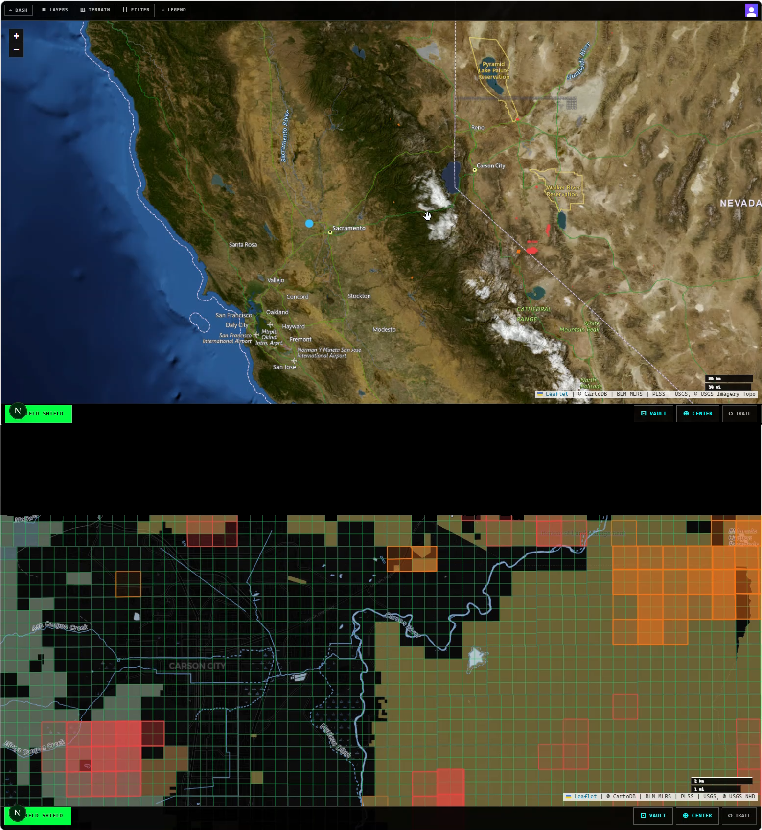
PRIVATE LAYER OVERLAYS FOR FIELD OPERATIONS

Upload your company's spatial data — claim boundaries, survey grids, access roads, exclusion zones. Every crew member sees your private layers overlaid on the live BLM and USGS data, online or offline.

PRIVATE LAYERS

Upload GeoJSON, KML, Shapefile, GPX, or CSV. Appears as named overlays on every crew member's map within seconds.

CROSS-REFERENCE

Every upload auto-checked against BLM claims, USGS mines, wilderness, military, native lands, and critical habitat. Critical warnings surface instantly.

FIELD SHIELD

GPS distance to nearest boundary — public OR private. Jurisdiction-aware statutory basis. Full audit log for every Field Shield event.

SESSION MEMORY

GPS tracks, Field Shield events, and active layers logged per session. Export to GeoJSON or CSV for review and compliance records.

BETA ACCESS

FREE
ALL MODULES — BETA PERIOD
  • Live BLM claims, unlimited downloads
  • 20-acre aliquot precision
  • USGS MRDS historic mine overlay
  • Auto-Square — Notice of Location PDF for county recorder filing
  • Field Shield — live GPS, BLM status & statutory basis full-screen overlay
  • Strike Pins — GPS-anchored field markers stored per session
  • Target Vault — offline claim profiles, no signal required
  • No credit card required
COMPANY TIER

FIELD OPERATIONS

$149/mo
UP TO 20 FIELD CREW MEMBERS
  • Private layer overlays — GeoJSON, KML, Shapefile, GPX, CSV
  • Upload once, all crew members see it on map — offline-first
  • Up to 20 field crew members
  • 5 GB private layer storage
  • Cross-reference engine — BLM, USGS mines, wilderness, native lands, critical habitat
  • Field Shield with private boundary distance math
  • GPS session tracking & Field Shield audit log
  • Company dashboard — analytics, layer management, export
  • 14-day free trial
GET COMPANY ACCESS
14-DAY FREE TRIAL — NO CARD REQUIRED
FIELD DISPATCHLEAVE A COMMENT
350 CHARS REMAINING